Discovery,
Find, Beginnings, Early,
Challenge, Breaking,
Paving, Residents,
Tourists, Kelly's, Conclusion
Kelly's
or "Half-Way Inn"
Although not confirmed, my research strongly suggests
that the forest service constructed these reservoirs for fire
control. I once speculated that the reservoirs were built to provide
water for the paving operation of the road. However, documentation
indicates all water was hauled to mix the cement.
An early undated map spots a forest station here, which would
coincide with the similar arrangement at National Forest Inn,
both having reservoirs and forest stations. A 1932 newspaper clipping
states, "New fire truck for Ridge Route. The new truck will
be stationed at Reservoir Summit." The reservoir at this
location was fed from a natural spring on Liebre Mountain just
above Sandberg's. A water pipe trailing along the road supplied
water to other sites as well. My research indicates the spring
is still active today, supplying water to the former Los Angeles
County fire station at the Pine Canyon-Ridge Route intersection.
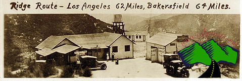
Our jouney at 19.7 miles places us as "Kelly's," which
is how it is indicated on early maps. Others mark it "Half
Way Inn." There was a Kelly Ranch in the canyon to the south,
but I have been unable to verify if Kelly's Ranch had any connection
with Half Way Inn. A newspaper clipping of May, 1925 states, "Joe
Palmer who maintained the National Forest Inn garage has purchased
the Kelly's place formerly operated by C.O. Cummings."
A topography map of 1926 reflects the site as Kelly's. Maps of
1931 and 1933 have it as Half Way Inn. The 1926 touring guide
states, "Half Way Inn; rooms, cabins, lunch, small garage."
They sold Richfield gasoline. A 1932 newspaper account references
a "Mr. & Mrs. Avis of the Half Way Inn." The Highway
Department had a repair yard and sand tower dispenser here used
to sand the road when it got icy. Located on the right hand side
of the road leading north, the yard was located on a small knoll.
It is difficult to find today, marked soley by power lines crossing
above the road and one remaining tree on the knoll.
Continuing our drive toward the summit, we reach Tumble Inn at
22. 1 miles. This site is on the left side of the road; it is
listed on topography maps of 1926, 1931, 1933 and 1937.The touring
guide of 1928 states: "rooms, dbl. $2, meals, gas, free camp
space, water and rest rooms. It is described as a small resort
with a far reaching vista. The buildings were constructed of round
stones, with the garage and lunch room structures level with the
grade of the highway. Steps to a higher terrain located the rest
rooms and lodge accommodations. The garage sold Richfield gasoline.
At some point in time, the name was changed to "Mountain
View Lodge." During road construction, this site was one
of the larger construction camps for workers. Today all that remains
is a stone retaining wall and the steps that once led to the sleeping
rooms.
Pushing on, at 23.3 miles we reach the Liebre State Highway Camp.
Here were various wooden barracks on both sides of the road in
addition to two long metal buildings on the west side of the highway.
The metal structures were similar to the one located at the National
Forest Inn. From this facility, crews maintained the highway.
Venturing to 24.1 miles we see "Granite Gate," today
marked by the large rock situated to the west. At one time prior
to shaving the cliff to the east, the road veered closer to the
monolith giving the appearance of a passage or "gate."
Our trip marks 24.6 miles locating "Horseshoe Curve".
A close look at the remaining pavement reveals that at one time
the road cut deeper into the cup of a horseshoe.
Sandberg's Summit Hotel, later called Sandberg's Lodge, at 26.0
miles, is located just north of Liebre Summit (4233 feet). The
hotel stood at 4,170 feet. A three story log hostelry set amid
a grove of California live oaks, Sandberg's was the high class
place. There is where one would see the Cadillacs, Packards and
Studebakers parked. They had a sign, "Truck Drivers and Dogs
Not Allowed." An early touring guide reflects: "Sandberg's
Summit Hotel, 25 good rooms in hotel and cottages; most with running
water and toilet; sgl, $1.50-$2.50; dbl $2-$4; lunch 85 cents,
dinner $1.00."
It was a small tourist community, post office, telephone and all-night
restaurant. It had a garage which gave al most complete service.
"Labor $2, after 6 p.m. $3; never closed." It was built
by Harold Sandberg in 1914. Various sources have purported him
as being Swedish, Swiss-German and Norwegian. Some articles indicate
his name as Hermann, others Harold. I checked the 1920 Los Angeles
County U.S. Census records and found a Harold Sandberg, native
of Norway. There was no Hermann listed. I can add in reference
to the name that Dave Cole provided me a copy of an original personalized
Christmas card that the Sandberg family mailed; it is signed Harold
Sandberg. (Dave is editor of'"The Way of the Zepher,"
a magazine of the Lincoln Zepher owners' club. Dave also has an
extensive collection of early maps without which I would have
been unable to identify accommodations available at various sites.)
The Sandberg Ranch was a short distance east on Pine Canyon Road,
and from here they supplied their hotel with fresh vegetables,
poultry and eggs.
Some articles have reported that Sandberg had gambling and prostitution.
This is entirely false. A man by the name of Fox acquired the
hotel after the Ridge Alternate opened and destroyed the "carriage
trade" on the old road. It was Fox that instituted gambling
and prostitution in the aging structure.
Lillian Grojean purchased the property from Fox and established
a pottery factory in the garage north of the lodge. It was during
Lillian's ownership that some accounts make the claim that messages
were being transmitted to the Germans during the Second World
War but these accounts appear to be nothing more than legend to
embellish Sandberg's Lodge history. Waiter "Lucky" Stevens
purchased Sandberg's from Grojean in 1950 and told me that although
she had some trouble with parking tickets, she had never been
arrested for transmitting messages to the Germans. As yet, I have
found nothing in newspaper archives to support the transmitter
story.
Lucky intended to turn the derelict property into a children's
camp. However, while renovation of the hotel was proceeding, sparks
from the fireplace ignited the roof and the hotel burned Apri129,
1961. The only thing remaining today is a stone wall and cement
footings where the hotel once stood.
We pull back onto the road continuing north again, past the old
county fire station on the right just beyond Pine Canyon Road,
and begin our descent into Antelope Valley. At the junction with
Highway 138 is an abandoned wooden house and oil tank. This was
the site of the General Petroleum Quail Lake Pumping Station.
The crude oil was received from the oil fields at Taft. At this
site the crude was heated and pumped to Willow Springs Pumping
Station and from there on to Mojave where it was loaded into tanker
cars for rail transport. It was called the "Bank Line"
because the oil was like.money running through it. (This information
was provided by Bonnie Kane, local historian in Frazier Park,
who is currently writing a book detailing history of the entire
Ridge Communities area.)
Just a short distance east of the pumping station we see a rather
large complex with an enclosed water tower. This was the Pacific
Telephone & Telegraph Booster Station built in 1929 to amplify
long distance circuits for the telephone cable being laid between
Los Angeles, Bakersfield and on to San Francisco. The location
was so remote that living quarters were provided for the men and
families that operated the station. They also provided electricity
to the families manning the oil pumping station, their neighbors
to the west.
Turning left onto Highway 138, we pass the Kinsey Mansion, once
part of the Bailey Ranch. General Petroleum (Mobil Oil Company)
purchased it from the Baileys for a duck hunting location for
their employees, directly across from Quail Lake (which in 1919
was identified as Crane Lake)!" This property had a small
cottage on it at that time. Later the property was purchased by
a Mr. Sattler of Gaffers & Sattlers Gas Ranges. A little farther
west was the Bailey Ranch house, which sat just east of some Arizona
Cypress trees on the southwestern shore of Quail Lake.
Quail Lake Inn, a short distance west of the Ranch house, also
on the right-hand side of the road, hosted a two-storied building
with a post office and rooms on the second floor. In back was
a family restaurant. They had two gas pumps and a tin garage.
We will turn right off of Highway 138 at our first opportunity,
accessing German Post Road, once the Ridge Route, and head toward
Gorman. At the top of the rise, with our mileage indicating 32.3
miles, we locate Holland's Summit Cafe. It was located on the
east side and was a trucker's joint. Tourists did not frequent
Holland's in the early days where trucks jammed the roadside as
well as the parking lot. It also had a Standard service station
and garage.
At the bottom of this summit was Caswell's at 33.0 miles. There
were ten rooms with running water in cottages, a double, $2, garage,
restaurant and a pay camp. The restaurant, garage and gas station
were located on the east side of the road with the auto camp and
store on the west.
At 36 miles we reach Gorman, previously known as Ralphs' Ranch.
The Ralphs family of supermarket fame purchased 2,700 acres back
in the 1890s, which include the township. The 1928 touring guide
states, "a small settlement: store, garage, cafe!" Ruth
Ralphs, the family's 74 year-old matriarch who still runs the
town post office, said, "We're getting older and as the family
gets larger we need to see to our tax and estate planning."
North of Gorman the old road is covered over with the present
I-5 freeway. About two miles north of Gorman was the small settlement
of Chandler, which was located just before the Frazier Park exit.
Today it is under the northbound lanes of the freeway. The site
was owned by a man named Chandler, and at one time there was a
motel, some small houses, a gas station, garage and restaurant.
The touring guide of 1926 indicates: Lodging, meals, small garage,
reputed reliable and good, labor $1.75 day or night. It is interesting
to note that a State Camp and cabins were under construction at
this location in 1928.
The last major structure in place during the highway's glory was
the Lebec Hotel. Construction began on January 15, 1921. The hotel
was the brainchild of entrepreneur Thomas O'Brien, a saloon-keeper
from Bakersfield. Financing for the opulent hotel was provided
by Cliff Durant, an automobile manufacturer.
The Lebec hotel was a "complete gambling joint with a ball-room,
rooms and apartments" during its heydays from 1925 to 1934.
Clark Gable and his actress wife, Carole Lombard, as well as gangster
Benny "Bugsy" Siegal, frequented the Lebec Hote1. A
1926 touring guide describes it: "Hotel Lebec is new and
high class, 80 rooms, thoroughly modern single $2-$3, with bath
$4, coffee shop open 24 hours."The Lebec Garage nearby was
the largest and best equipped on the ridge. Labor was $1.75 an
hour, increasing to $2.40 after 6 p.m.
Shortly after the hotel opened, Durant sold his interest to Foster
Curry (son of the concessionaire at Yosemite) of San Francisco.
Early postcards from this period show the hotel under its brief
stint as "Curry's Lebec Lodge," once located along the
west side of Lebec Road just north of the Lebec off-ramp.
The hotel fell into disrepair and was officially closed on November
13, 1968, in response to health department charges concerning
its substandard water system and dilapidated condition. The hotel
went into receivership and was purchased by the Tejon Ranch Company.
They torched the hotel and demolished the remains on April 27,
1971, only two weeks after acquiring the property. Two tall Italian
Cypress trees mark the former location.
The Ridge Route passed directly in front of the hotel and continued
toward Fort Tejon and Grapevine, the small community at the bottom
of the grade. Just north of the hotel was Shady Inn, located on
the present site of the Lebec Community Church. It was one of
the most popular auto camps of that era. The 1928 touring guide
states: "25 cents, water, comfort stations, lights, tables
& benches, shade or shelter, 3 cabins $1 $1.25; noted for
good meals, 50 cents."
Just up the road was Fort Tejon, a supply point, garage and cafe.
The ruins of the old fort were one quarter mile to the west.
Two
miles beyond the fort was Camp Tejon which had a service station
and auto camp. The cost of the auto camp was 50 cents and included
water, lights, comfort stations, tables and benches with a community
kitchen or cook house. For $1.50 you could rent one of the six
cabins at the site.
Another half mile located Combs Service station and repair shop.
From this point the early motorist continued down the grade until
he reached Grapevine, also known as Grapevine Station. This was
a small community of oil pumping station workers, with "good
modern rooms" in cottages, dbl. $3, lunch room and soda fountain,
one garage, open camp space.
We will end our journey here at the bottom of the Grapevine. When
the current I-5 was constructed, the town of Grapevine was isolated
from any access and, in effect, disappeared. A few derelict buildings
remain. Although the I- 5 freeway destroyed much of the remaining
segments of the old road after it left Gorman, we have experienced
the encounters of the early motorist.
The original Ridge Route was constructed, graded and paved at
an approximate cost of $1,500,000. As traffic increased in volume
and speed, the sharpest curves of the Ridge route were "day-lighted"
but by 1929 it became apparent that any further major improvement
on this highway would not be justified in proportion to the resulting
savings to traffic, thus marking the end of the road.
click
here for next page